
Cliente
RETINA
RETINA
Castejón, Navarra
RIS Iberia S.L., Spherag Teck IOT, Constellr y GFZ POSTDAM
El proyecto RETINA buscaba establecer la metodología fundamental de búsqueda más robusta y temprana del estrés hídrico, para la optimización de modelos de riego inteligente. Esto se basará en datos de teledetección TIR (infrarrojo térmico) junto con sensores in situ (temperatura y la humedad del suelo y del aire) y un tratamiento de campo totalmente automatizado (riego inteligente).
El uso adecuado de los insumos a través de sistemas automatizados tiene un impacto directo y significativo en la productividad, rentabilidad y calidad de vida de los agricultores (reducir el esfuerzo de mantenimiento). La toma de decisiones basada en datos científicos reducirá el impacto de la pérdida de conocimiento que se produce por el relevo generacional.
Los participantes en este consorcio representan toda la cadena de valor del riego inteligente. CONSTELLR proporciona servicios de monitoreo de temperatura basados en imágenes hiperespectrales y satelitales e índices NDVI; SPHERAG IoT, tiene equipos IoT que permiten conectar cualquier dispositivo habitual en una finca de riego, como válvulas, motores, bombas, filtros, proporcionando una solución holística aplicable a cualquier escala, mediante una plataforma accesible desde cualquier dispositivo móvil, las cuales RIS Iberia conoce perfectamente, al tratar con agricultores y ganaderos en su día a día, ofreciendo la solución para riego remoto y sensores in-situ, ambos compatibles con la plataforma de Spherag y GFZ se ha encargado del procesamiento y análisis de datos hiperespectrales. Los datos de la misión hiperespectral de EnMAP y PRISMA se analizaron en términos de parámetros sólidos y de cultivos para detectar estrés hídrico.


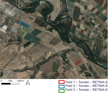
Localización: El proyecto localizó las fincas que estuvieron en el estudio, en el área de Castejón, población de Navarra, donde las condiciones eran inmejorables, asegurando la equidad de las condiciones de los suelos de las fincas y sus cultivos.
Trabajos realizados: Durante el año y medio que ha durado el proyecto se ha realizado el seguimiento por parte de todos los operadores del equipo, de todos los datos recogidos, que posteriormente fueron incluidos y analizados por la plataforma de recomendación de riego, que permitirá la automatización por parte de los algoritmos de la plataforma. Los datos que se han recogido son:
Datos visuales:
– Físicamente por parte de los operadores e instaladores del cliente.
– Vuelos periódicos del dron para implementarlos en la plataforma.
– Todo este seguimiento facilitó la creación de un Gemelo virtual de las fincas en la plataforma.
Datos térmicos:
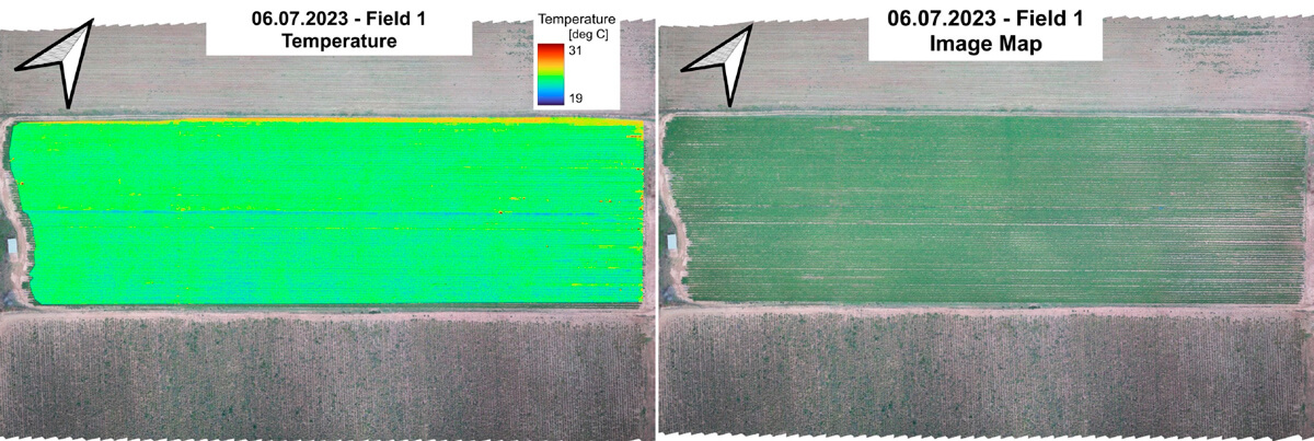
– Un dron térmico realizó vuelos regularmente, para alinearlos con los pasos elevados de los satélites Sentinel 2A y Sentinel 2B.
– Los vuelos del dron se llevaron a cabo más o menos a 3 horas de los pasos de Sentinel 2 para aumentar la calidad de la clasificación de los datos de drones con los datos satelitales.
Datos de Campo:
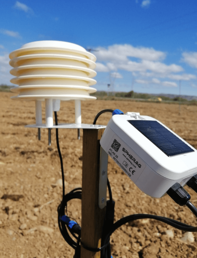
– Los datos de temperatura y humedad relativa ambiente se recopilaron utilizando los equipos Atlas de la empresa Spherag. Los dispositivos Atlas, incorporando los sensores necesarios de alta calidad, recopilaron estos datos con precisión durante la duración del proyecto y dada su conectividad en tiempo real, almacenaba el histórico en la plataforma, permitiendo ser accesible por todos los agentes del equipo, en todo momento.
– Dichos equipos Atlas, fueron instalados y revisados durante todo el proyecto por parte del personal de RIS Iberia y de Spherag.
Datos Hiperespectrales:
– Los datos HYP fueron tomados por el satélite PRISMA, que había sido testeado previamente en la primera anualidad.
En lugar de regar toda la finca de una sola vez, se ha implementado una estrategia inteligente: dividir el riego en parcelas. Cada área recibe agua según sus necesidades específicas. Las válvulas RIS Valves automatizadas destacan en esta gestión precisa y eficiente. Los agricultores pueden confiar en que cada almendro reciba la cantidad adecuada de agua sin desperdiciar recursos.
El proyecto llevado a cabo por el consorcio avanzó significativamente a pesar de algunos desafíos técnicos y temporales sufridos. La recopilación y análisis de datos, junto con la instalación de equipos de monitoreo, permitieron obtener informacion valiosa sobre las condiciones de las parcelas y el rendimiento de los cultivos.
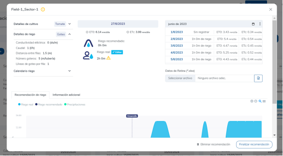
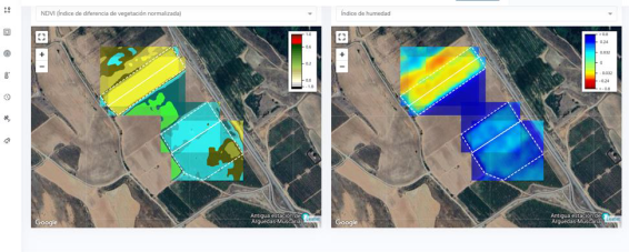
Los modelos de recomendación han sido desarrollados cumpliendo los hitos establecidos y se han conseguido todos los resultados/objetivos proyectados inicialmente. Entre todos los hitos, queremos resaltar la integración de todos los datos, basados en los sensores locales, datos NDVI de las imágenes satelitales, y las imágenes TIR y HYP, y el desarrollo e integración de ambos modelos de recomendación en una única plataforma accesible en tiempo real desde cualquier dispositivo con conexión a internet desde cualquier punto del planeta.
Podemos decir con cierta confianza que se deriva una buena correlación entre el LST y la salud/rendimiento de los cultivos. Las imágenes mostradas un poco más arriba en la página, muestran una serie temporal, donde se observa que las áreas con mayor temperatura corresponde a las zonas con menos áreas verdes.
Tradicionalmente el sector agrícola riega excesivamente los cultivos. Un buen uso de imágenes hyperespectrales darán lugar a ahorros muy significativos en el consumo de agua y de fertilizantes.
La información que podemos dar las empresas del consorcio a las empresas y autónomos del sector agrario abre nuevas líneas de negocio, gracias a las recomendaciones de riego que dan plataformas como la de la empresa SPHERAG IoT.
Concluyendo decimos que somos capaces de realizar una recomendación de riego eficaz, gracias a los dispositivos de SPHERAG, el análisis de CONSTELLR y GPZ de las imágenes TIR y HYP y la eficiente creación de la plataforma de recomendaciones que los usuarios finales pueden tener en la palma de la mano.

Pol. Industrial Centrovía
C/ Los Ángeles Nº9, Naves 3 y 4
50196 La Muela Zaragoza
T: (+34) 976 144 700
E: risiberia@risiberia.es
© 2026 Ris Iberia, S. L. Web por Siroko.Studio